
Rock marks can fish at several tide stages, but safe access is the first constraint. Note escape routes before the flood and expect stronger tackle around snags.
Pollachius virens
Identification, season, habitat, bait, rigs and TideDeck shore marks relevant to Coalfish.
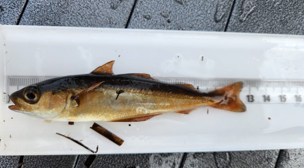
Dark-backed cod-family fish with a pale, nearly straight lateral line and projecting lower jaw.
Rocky coasts, piers, harbours and deeper structure.
Most prominent around northern Britain but can occur farther south.
Broad UK context, not confirmation of presence at every compatible mark.
Can be taken in daylight or darkness around structure and moving water.
Lure, float and bottom tackle can all be relevant depending on mark and fish size.
Compare identification features with:
Coalfish is a UK shore-angling target associated with rock, harbour, mixed. Commonest around northern rocky coasts and structures, often mixed with pollack.
Typical UK shore season: Sep–Apr. Timing varies around the UK with water temperature, region and weather, so treat the season as a planning range rather than a promise.
Useful ground types include rock, harbour, mixed. Fish position within a mark can change with tide stage, daylight, swell and food availability.
Common baits: mackerel strip, lures, worm.
Common rigs or methods: float, lure, flapper.
Use the linked TideDeck bait, rig, month and location pages to build a session plan. Check current local rules and recent reports before travelling, especially where species availability or conservation measures can change.
Broad UK shore-fishing guidance; regional timing and water temperature can shift availability.
These are ground-type principles, not mark-specific claims. Use the live TideDeck page for the mark you plan to fish.
Rock marks can fish at several tide stages, but safe access is the first constraint. Note escape routes before the flood and expect stronger tackle around snags.
Harbours and piers can offer depth through more of the tide. Moving water around structures is often more important than simply aiming for high water.
Mixed ground rewards finding the boundary between clean sand and rougher structure. Moving water across that edge can concentrate food and fish.
Ground-type matches for planning and research, not confirmed catches or a claim that the species will be present.